


History
- Home
- English
- Discover Naha Port
- History
History of Naha Port
At the southernmost tip of Japan, Naha Port is the gateway to Okinawa Prefecture for both travelers and goods. When the region was united as the Ryukyu Kingdom by Sho Hashi in the 15th century, the port prospered as a channel of trade among Japan, China, Korea, and Southeast Asia and subsequently became the primary base for Ryukyu trade.
Before Naha Port (present day Naha Wharf ) was designated as the base for trade by Sho Hashi, Eiso, King of Chuzan (1229-1299), had built an official mansion (Tomari Goten ) and public storehouse (Oshima Storehouse) at Tomari Port (present day Tomari Wharf) to serve as the royal government’s port, from which he opened trade with China in the 14th century.
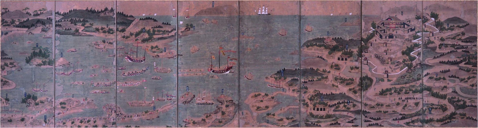
Map of Naha Port circa 1422 (from the Okinawa Prefectural Museum and Art Museum collection )
* Click on images for larger view (Unauthorized use of images is strictly prohibited)
Prewar Naha Port
Extensive development of the port’s facilities began in 1907, and by 1915, the port was large enough to moor three 1,200-ton class vessels at the same time.
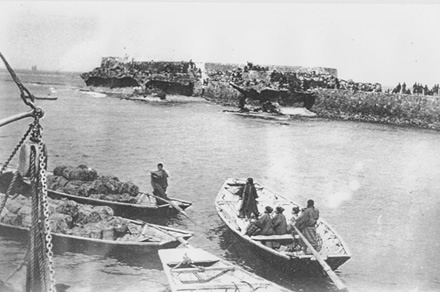
Seeing off passengers at Mi Gusuku Castle (present day Naha Wharf) circa 1927. Before the pier was constructed, passengers and goods were carried by ferry boat to ships docked at port.
The port was subsequently expanded several times. Before the outbreak of World War II, port facilities were able to accommodate one 4,500-ton class vessel and three 2,000-ton class vessels at the same time.
However, Naha Port was destroyed in air raids by U.S. forces in 1944, and the facilities were rendered unusable.
Postwar Naha Port
At the end of World War II, the destroyed port was taken over by the U.S. military, which undertook extensive renovations of both Naha and Tomari Port. Following this, Naha Port was able to accommodate 20,000-ton class vessels, and Tomari Port was able to accommodate 3,000-ton class vessels.
In 1954, the northern piers of Naha Port were returned to be managed and operated by what was then the government of the Ryukyu islands , and Tomari Port went to Naha City in the same way. As the Okinawan economy recovered after the war, the ports were handling increasingly large volumes of cargo each year. By 1965, the existing facilities could no longer handle the cargo coming in, and expanding the ports and harbors became a matter of urgency.
Plans to construct Shinko Port in the Aja district were drawn up, and construction began in 1969. In 1971, three quay wall berths with a depth of 7.5 meters and one quay wall berth with a depth of 6.0 meters were completed, and the port opened for service.
Naha Port After Return
When the ports were returned to Japan in 1972, the northern piers of Naha Port, Tomari Port, and Shinko Port were unified under Naha City management. With the integration of these three harbors, Naha Port was designated a major port.
The Naha Port Development Plan, enacted in 1974, introduced plans for Urasoe Wharf, which would improve distribution infrastructure connecting Okinawa with mainland Japan and neighboring countries in Asia, as well as connecting the main islands within Okinawa. With the construction of Naminoue Bridge, Tomari Bridge , and Naura Bridge, port development would contribute significantly to daily life in local communities and promote industry and tourism, as well.
In the mid-1980s, it became necessary to adapt to changes associated with the expanding infrastructure for the distribution of goods, such as rising cargo volumes, the increasing size of ships, and shifts in forms of transportation. In addition, given the seaside location of the ports in Naha, the neighborhood was expected to play a role both as an industrial base and an area for recreation and relaxation for local residents.
In order to meet the needs of the time, the Naha Port Development Plan was revised in 1988, highlighting expansion of Shinko Wharf piers and enlarging the Urasoe Wharf northward.
This was followed with improvements focused primarily on adapting to the shift toward container shipping, redeveloping Tomari Wharf, developing the seaside park, and refitting the harbors for small ships. Tomarin (the Tomari port building) was completed in 1995, and the Tsuji side of Naminoue Beach opened in 1998, creating a popular recreation area in Naha Port. At Shinko Wharf, the No. 1 Berth opened for international containers in 1997, and the first quay cranes came into use in 1998.
Naha Port Authority Established
In April 2002, the management and operation of Naha Port was transferred from Naha City to the Naha Port Authority, a joint body including the Okinawa Prefectural government and the Naha and Urasoe municipal governments.
In 2003, based on the Okinawa Promotion Plan, the focus shifted to expanding Naha Port to handle international logistics. The Naha Port Development Plan was therefore revised to reflect a basic policy of enhancing the port’s international logistics functions, promoting international tourism and the resort industry, restructuring the port’s functions, fostering and protecting the environment, and ensuring safety and security.
Based on this revision, Naha Port was expanded in 2004 to include the installation of the No. 2 quay crane in the Shinko Wharf area. In 2006, the No. 2 Berth for international containers with a depth of 13 meters was constructed and the law on Special Zones for Structural Reform was utilized to privatize the Naha Port International Container Terminal (operated by Naha International Container Terminal, Inc.).
From 2014 to 2015, the No. 3 and No. 4 quay cranes were added to the two existing quay cranes, as well as a two-unit, one berth system with minimal maintenance requirements. Today, Naha Port International Container Terminal services regular international container routes (to/from North America, nearby sea routes, and Southeast Asia).
The opening of the Airport Access section of Rinko Doro Road and Naha Nishi Road (Naha Umisora Tunnel) in 2011 and the Urasoe section of Rinko Doro Road in 2018 strengthened logistics between Naha Port and the loading and supply area. These moves also improved accessibility between Naha Port and Naha Airport, as well as a number of other locations throughout the prefecture.
Following the provisional use of Tomari Wharf berths for large passenger ships, the Naha Cruise Terminal began operations to accommodate cruise ships in April 2014. With this new terminal, passengers were now able to disembark as soon as their ship arrived at port, helping to boost tourist convenience and satisfaction.
History of Naha Port
| 1264 | King Chuzan of Urasoe Castle develops Tomari Port (present day Tomari Wharf) as the kingdom’s official port. |
|---|---|
| 1422 | King Sho Hashi, the unifier of the Okinawa islands, designates Naha Port (present day Naha Wharf) as the base for all trade with China. From this point, Naha Port flourishes as an intermediary in trade between Southeast Asia and mainland Japan. |
| 1452 | During the reign of King Sho Kinpuku, Sho Hashi’s third son, Naha Port surpasses Tomari Port to become the kingdom’s main port. At the time, Naha constitutes an island nation. Minister Kaiki , a Chinese national, builds an inter-island causeway called Choko Bridge, connecting Kumoji Chinmasa with Asato Bridge (present day Sogenji Bridge). With the new bridge in place, ships from a number of different countries anchor at Naha Port. |
| 1609 | Although the Ryukyus are invaded by Satsuma Clan troops, trading with the Ming Dynasty is permitted to continue. |
| 1853 | Commodore Matthew Perry of the U.S. Navy arrives. He visits Shuri Castle and creates a map of the island and its surroundings. |
| 1879 | Feudal domains are abolished. Steamships, called “fire engines,” now use the port as a point of entry. |
| 1884 | Regular ferry service is established between Naha and mainland Japan (Kagoshima and Osaka). |
| 1907 | Successive governments focus on harbor construction. Governor Shigeru Narahara budgets for the first phase and oversees the start of construction. Construction continues throughout the governorships of Shigeaki Hibi and Takuya Takahashi and is completed in 1915 under the governorship of Kyugoro Omi. A piled wharf is constructed to allow three 1,500-ton steamships to moor side by side. |
| 1921 | Construction begins on quay walls a depth of 7.5 meters at Naha Port and is completed in 1925. |
| 1944 | U.S. military air raids destroy Naha Port facilities, rendering the port unusable. |
| 1951 | U.S. military begins reconstruction of Naha and Tomari Ports. |
| 1954 | The northern piers of Naha Port are transferred to the Government of the Ryukyu Islands.The southern piers are designated a U. S. military port area.Tomari Port operations are transferred to Naha City. |
| 1969 | Naha City begins construction of Naha Shinko Port (present day Shinko Wharf). |
| 1972 | Just prior to Okinawa's reversion to Japan, the ports of Naha, Tomari, and Shinko are unified into today's Naha Port, and put under centralized management and operations. |
| 1974 | The Naha Port Development Plan is formulated. With the construction of the Naminoue, Tomari Ohashi, and Naura bridges, the plan contributes significantly to the daily lives of the local communities, as well as to the promotion of industry and tourism. |
| 1983 | The first Shinko Port breakwater is completed. |
| 1984 | Shinko Wharf quay walls (7.5 – 11 meters) are completed. Naminoue Bridge opens. |
| 1985 | Tomari Bridge opens. |
| 1993 | Naura Bridge opens. |
| 1995 | Tomarin port building is completed. |
| 1997 | Construction on submerged tunnel begins. Container-dedicated quay wall (Depth: 13 m; No. 9 Wharf) berth begins operations. |
| 1998 | No. 1 quay crane begins operations. |
| 2002 | The Naha Port Authority is established as a special local public entity, a joint body including the Okinawa Prefectural government and the Naha and Urasoe municipal governments. The port authority’s mission is to ensure proper and efficient port management and administration, as well as promote the development and use of Naha Port. |
| 2003 | Revision of the Naha Port Development Plan is approved. The Transshipping Port Zone and the Ocean Environment Conservation Zone are incorporated in the plan. |
| 2004 | No. 2 quay crane begins operations. International bidding is opened to select the administrator of the Naha Port International Container Terminal Project. The winning bid will consolidate management and operation of Shinko Wharf No. 9 and No. 10 Berths under the special zone system. |
| 2005 | Naha International Container Terminal, Inc., comprising the global operator ICTSI, headquartered in the Philippines, and six prefectural port operators, is selected to manage and operate the Naha Port International Container Terminal Project and concludes a lease agreement with the Naha Port Authority. Minor changes to the port plan result in a change of location for large passenger ship berths from Shinko Wharf to Tomari Wharf (in front of the green area of Wakasa Seaside Park ). |
| 2006 | Japan’s first purely private-run terminal operations begin. Naha International Container Terminal, Inc. (NICTI) begins managerial operations. The goal is to reduce maritime shipping costs by increasing the volume of cargo, primarily transshipping cargo. |
| 2009 | Provisional use of Tomari Wharf large passenger ship berths begins. |
| 2010 | Naha Port Development Plan partially revised. The land development and land use plans are revised to accommodate a change from landfill construction to bridge format for the northern 1.0km of the 2.5km Urasoe section of Rinko Doro Road. |
| 2011 | Naha Umisora Tunnel begins operations. |
| 2012 | Naha Port Development Plan partially revised. The Wakasa-minato-machi section of Rinko Doro Road is developed and the land use plan revised accordingly to address the increase in traffic volume between Shinko Wharf and its loading and supply area. |
| 2013 | Naminoue Umi-sora Park opens. |
| 2014 | Naha Cruise Terminal begins operations. No. 3 quay crane begins operations. |
| 2015 | No. 4 quay crane begins operations. |
| 2016 | Naha Port Development Plan partially revised. Plans are developed for a public wharf and passenger ship wharf, and the harbor facilities and other plans revised accordingly to address the increasingly large size of transport vessels and increased demand for cruises at Shinko Wharf area. |


- 〒900-0035 2-1 Tondo-cho, Naha-shi, Okinawa
Copyright(c) Naha Port Authority All rights reserved.